Enjoy this extended Indian Summer while you can, and in spite of election tension and anxiety. It's all going to change later this week.
The National Weather Service put out a set of figures for a dozen Bay Area locations showing exactly how unusual this October was both in terms of lack of precipitation, and in average temperatures. There wasn't a drop of rain anywhere, as you likely know, despite average rainfall being as much as an inch in a normal October. And average temps were between 4 and 6 percent above normal.
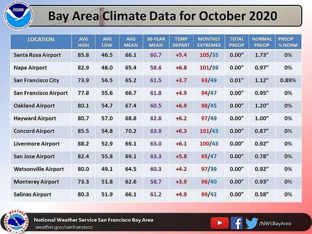
The mean temperature at SFO was second only to 2014's, coming in at 66.7 degrees — with the 30-year mean being 61.8 degrees.
San Jose saw an average high temp of 82.4 degrees, with an average mean of 69.1 — the highest on record. And downtown San Francisco saw its fourth hottest October on record.
All of this is going to change rapidly between Thursday and Friday, as the NWS says in its Monday forecast discussion, with a 20-degree drop that will make some very chilly mornings.
"Seasonably warm weather pattern continues through Thursday with high pressure bringing warm days followed by mostly clear and cool nights," the NWS writes. "A cold front arrives Friday with much colder daytime highs falling into the lower 60s."
Highs in San Francisco may hit the lower 60s, but that means nighttime lows of 48 on Friday and Saturday, and 43 by the time you get to Monday, per Weather Underground. Brrrr.
It's finally going to feel like fall 🍂. A big pattern change is still being forecast on Friday & over the weekend. A cold front will bring much cooler 📉 weather and blustery 🌬️ conditions on Friday. A few scattered showers will be possible on Friday & over the weekend. #CAwx pic.twitter.com/AP3taglUBY
— NWS Bay Area (@NWSBayArea) November 3, 2020
Forecaster David King tells SFGate that rain, if it comes, is likely to hit the North Bay primarily. The weather system arriving Saturday will likely bring the most rain to the Pacific Northwest, with northern parts of the Bay Area seeing the most hope for some long-awaited moisture.
Sadly, we're still probably waiting for next week or the week after that for any real, impactful rainfall. And this is a La Nina year, so, who knows.
Photo: Chris LaBasco / Getty Images