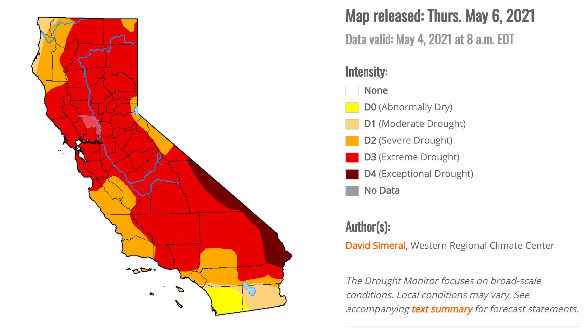
SF may be "yellow" on the COVID reopening map, but a different map has us in the "red." Just two weeks after categorizing the region as being in a "severe" drought, the U.S. Drought Monitor has updated its map and put the entire Bay Area in the second-worst category for drought conditions.
Based on measurements of precipitation, soil moisture, river levels, and other factors, the federal drought authority said Monday that a large swath of California is now in "extreme drought" status. While Sacramento County and some parts of Northern California have been in the red-designated "extreme" category for a number of weeks, the Bay Area had been in the orange or "severe" category as of April 20. Last week, a lot of the Bay Area entered the red, but parts of Alameda, Santa Clara and San Mateo counties were still in the less dry category.
Now, as the Chronicle reports, the red swath of California has grown, and it covers about three-quarters of the state. The only part of the state that appears to be doing OK, moisture-wise, is San Diego County, which is designated yellow or "abnormally dry."
It's still the first week of May, and barring some unforeseen, late-season rain, the situation is only going to get worse — and already California has seen twice as many wildfires break out this year, 1,575 in total, than the average for the past five years for this date. Last year at this time, there had been 938 fires to date, according to Cal Fire.
About half of Nevada and Arizona are currently in the most extreme, "exceptional" drought category, but the majority of California has not yet reached that stage.

In its summary for the week, the U.S. Drought Monitor said that the expansion of the D3 "Extreme Drought" zone came after the "very dry April" we just had.
In California, areas of Extreme Drought (D3) expanded across the northern and central Sierra Nevada, as well as in areas of the San Joaquin Valley where water deliveries have been severely reduced due to the poor snowpack conditions across the Sierra (59% of normal on April 1 statewide) and below normal reservoir conditions. For the Water Year (since October 1), precipitation across most of California has been much below normal (bottom 10th percentile) with some locations—including areas of southeastern California, and the greater Bay Area—experiencing record or near-record dryness.
David Simeral, of the Western Regional Climate Center, and Richard Tinker of the National Weather Service and National Oceanic and Atmospheric Administration (NOAA) noted that California's two largest reservoirs, Lake Shasta and Lake Oroville, were at 50% and 42% of capacity as of May 4. They said that, for California, "conditions deteriorated on this week’s map in response to a combination of factors including back-to-back dry water years, above-normal temperatures, below-normal snowpack, and drought impacts (agricultural, ecosystem health, water supply, recreation)."
Marin County has already begun imposing water-use restrictions on its water customers, including limiting sprinkler use in yards to twice a week.
And two weeks ago, Governor Gavin Newsom declared an "extreme drought emergency" in Mendocino and Sonoma counties, triggering some water allocation changes there.
San Francisco does not yet have any mandatory restrictions — and reportedly our water supply from the Hetch Hetchy Reservoir and other sources stands at 76.8% of capacity. Last week, the SF Public Utilities Commission asked city departments and irrigation customers to voluntarily reduce their water use by 10%.