According to a recently released map and study conducted by the USGS (United States Geological Survey), East Bay and San Jose are far more susceptible to damaging seismic shake-ups than previously thought, not made better by the fact that those areas are, apparently, sitting on sand.
As reported by KPIX, areas in both the East and South Bay are more at risk of experiencing future seismic events in the next 100 years than understood, prior. The USGS published an update to their National Seismic Hazard Model (NSHM) Thursday, showing a 75 percent or higher chance of a damaging quake hitting the Bay Area in the next century; no stretch of the Bay Area, now, seems to be omitted from that postulated cataclysm.
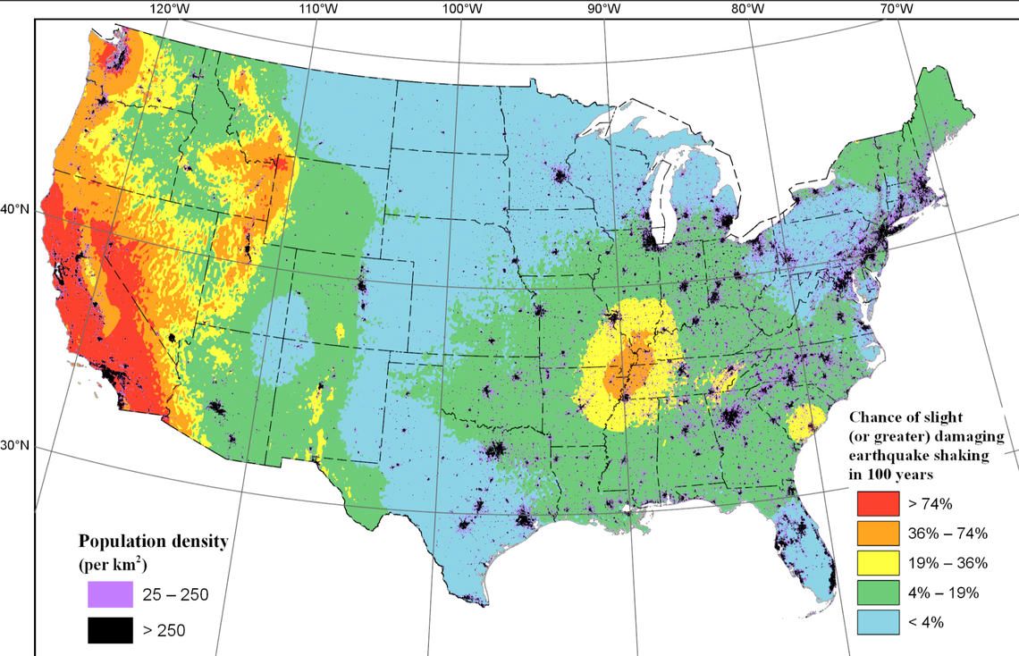
These new maps are probabilistic maps, not ShakeMaps – the ones that are near-real-time maps of ground motion and shaking intensity following significant earthquakes – and paint a hypothesized picture, showing data-backed inferences on the probability a quake will happen in an area.
Oddly enough, it's not the structures, even the towering ones, in those areas that have seismologists and geologists concerned: It's the actual ground they're founded on, as highlighted in the published full report. Soil analysis conducted by the USGS showed areas in Concord, Walnut Creek, San Jose, and Vallejo sit on sediment basins ... so, basically, massive sand pits.
“We worry about taller buildings in the basins,” Mark Petersen, a USGS research geophysicist who worked on the study, told Pasadena News Now on the update. “The fact that [these sediment basins are] so deep is what we worry about. The update helps us to understand better, in more detail for different types of levels.”
Unlike, say, ravines made from harder, denser limestone and igneous rock, the quasi-liquid-acting nature of these sedimentary basins helps amplify an earthquake’s elongated waves, the ones responsible for taking down tall buildings and long bridges. These sand basins – like one in Los Angeles, as deep as Mount Everest is tall – are, essentially, filled with a mix of sand, silt, and clay, which can also cause structures to sink, once those wavelengths disturb the sediment columns.
Compounding the worry further, the USGS says current building codes in those areas don't (and, at the time of their construction, couldn't) take into account these new calculations, leaving already erected structures vulnerable to damage and possible collapse.
However, these new findings will serve as the foundation for new building codes and construction parameters; the USGS, too, intends for these statistics to serve as a means to prepare for the future, not to fear monger in the present.
Related: Three More Small Earthquakes Rattle Hollister Area Tuesday Morning
New Study Finds That Most Big Earthquakes Are Preceded By Smaller Foreshocks
Image: Public Domain via USGS