After Tuesday's storm and more scattered showers expected today, the Bay Area has had a more than thorough drenching and the snowpack in the Sierra could rise over 200 percent of normal for this time in the season by tomorrow. But with some parts of the region getting over a foot of rain in the last seven days, all kinds of problems continue to be happening, including some tense evacuations Tuesday night and more toppled trees and landslides than can be thoroughly tallied as of yet.
San Francisco has gotten over five inches of rain in the last week, more than we'd typically get in an average winter month, and the Bay Area record appears to be in the hillside town of Venado in Sonoma County, which clocked over 21 inches in seven days.
Dozens of people had to be rescued from severe flooding in part of Hollister Wednesday morning, as ABC 7 reports. That was the result of the overflowing of Pacheco Creek, and you can see some chopper shots of that from KRON 4 below.
As San Anselmo Creek crested its banks Tuesday evening in Marin County, a mandatory evacuation order was issued there at 6:40 p.m. as ABC 7 reports. The Chronicle reports that Corte Madera Creek also overflowed, and downtown businesses and homes were evacuated as a precaution.
Flood horns just sounded. Evacuation order #now pic.twitter.com/wucfqMAwOL
— Lisa Amin Gulezian (@LisaAminABC7) January 11, 2017
In nearby Fairfax, according to KRON 4, a family had to be rescued Tuesday night after a fallen tree and a mudslide trapped them inside their home.
According to the Chronicle, an early morning landslide Wednesday closed Niles Canyon Road between Fremont and Sunol, and a separate landslide displaced a family in Sunol.
In San Francisco, a landslide was reported Tuesday on part of O’Shaughnessy Boulevard in the Diamond Heights neighborhood, per the Examiner, and there was minor flooding all day along the Embarcadero, as ABC 7 shows us, helped on by King Tides. And the biggest problem came when two BART trains struck a fallen tree or tree limb outside Balboa Park Station Tuesday during the height of rush hour, shutting down service in both directions between 24th Street and Colma, and causing systemwide delays.
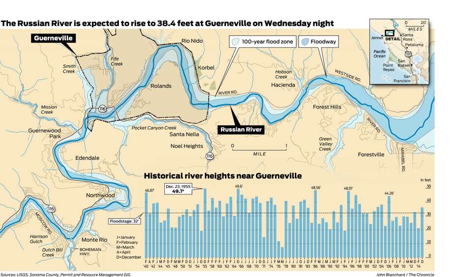
But the most dramatic and widespread flooding from the storm remains up in western Sonoma along the Russian River, where an earlier estimate on Monday had the river cresting at 35 feet, or three feet above flood stage, and that's been revised after Tuesday's storm to be between 37.7 feet and 38.4 feet. This still won't make it as bad of a flood as happened on New Year's Day 2006, when waters rose to 44 feet, or the record of the last century in 1955 when they rose to 49.7 feet. (The Chronicle has a bar graph showing the river's frequent floods over time.) As of Tuesday, "firefighters were patrolling on Jet Skis and families were taking canoe rides down residential streets," and while much of the town is built with floods in mind, it remains to be seen how extensive the damage may be this time around.
1700 people in the area are under an evacuation advisory, as ABC 7 reports, with some of the most vulnerable in low-lying mobile home parks.
And, even on Monday, there were plenty of photos of the Playland mini-golf course under a couple feet of water, and that's only gotten deeper.
It looks like we can breathe easier now, with a bit of rain expected through tomorrow, and a dry and even sunny week ahead.