Two La Niña winters in a row is probably not great for this drought we're in — when a really wet and relentless El Niño season is what we need right now. But let's just hope for average or slightly above average rainfall, unlike last winter.
Back in August, we were already on La Niña Watch, with forecasters at the Climate Prediction Center saying there was a 60% chance of another La Niña pattern forming. And now, as CNN reports, the center issued its La Niña advisory today, saying, "La Niña is anticipated to affect temperature and precipitation across the United States during the upcoming months."
As discussed before on this site, a La Niña pattern holds no guarantees of drier or wetter conditions for this part of the world — we are basically sandwiched between the two and things could swing one way or the other. Patterns, also, may be shifting due to climate change, and predictions based on the history of La Niña winters may be unwise.
The prevailing wisdom is that a La Niña winter brings a wetter winter to the Pacific Northwest, and a drier, warmer winter to Southern California, the Southwest, and the South. Last year, we held out hope that we would get some extra rain in the Bay Area coming down from the north, after an exhausting and smoke-filled fire season, but that never came to pass.
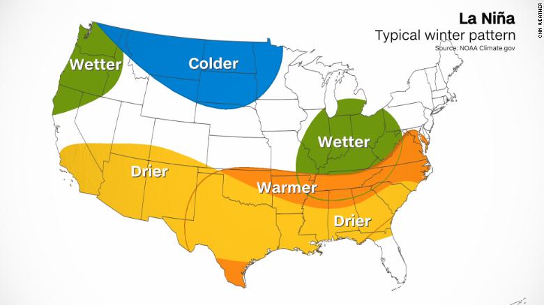
On average, for this region, La Niña winters start off dry but the rain and snow may catch up to normal levels by later in the season. Last year, that didn't happen.
Two Februarys in a row, the Bay Area has seen little to no rain, which is strange in any year. This year there was a set of late January storms followed by a historically dry February, and in February 2020, 0.00 inches of rain fell. Any Miracle March was elusive as well, even though fewer people were clamoring to ski since we were in a pandemic.
Another La Niña could also be disastrous for the Atlantic hurricane season.
"La Niña is associated with reductions in vertical wind shear in the Caribbean and tropical Atlantic," says Phil Klotzbach, a research scientist at Colorado State University, speaking to CNN. "Too much shear is typically what ends the Atlantic hurricane season, so La Niña can extend the active part of the season."
Klotzbach adds that no one is predicting a super-active end to the hurricane season, but the La Niña confirmation means that a big late-season storm is more possible now.
Overall temperatures tend to go down globally in a La Niña year, but as CNN notes, this is where climate change appears to be upending historical patterns — and human-induced warming appears to be overwhelming the planet's natural patterns. The best example: 2020, which was a La Niña year, is tied with 2016, an El Niño year, for the hottest on record.
The National Oceanic and Atmospheric Administration will release its official winter outlook next week, on October 21.