Your supervisorial district gets changed slightly every ten years after the Census is completed, and that process is getting underway for next year.
Certified results for the 2020 U.S. Census will start getting released this week, and as such, congressional districts across American will be redrawn to reflect population changes. California is expected to lose a congressional seat for the first time in decades, while Florida and Texas are expected to pick up seats. You will also see your California State Senate and State Assembly districts redrawn, and the process even trickles down to individual San Francisco street block designations for who represents you at City Hall. The 11 SF supervisor districts will also be redrawn, and SF Public Press reports the city is getting ready to start drawing new supervisorial districts.
San Francisco’s supervisorial redistricting is not the political power grab contest between Democrats and Republicans the way it is for federal House of Representatives seats, or California state senate and assembly districts. Here it’s more a set of neighborhood squabbles (Some Nob Hill residents, for instance, are not thrilled to be in the Tenderloin’s district). But this issue doesn't really rile up conflict between moderates and progressives on the Board of Supervisors, and the disputes are more among small groups of neighborhood activists.
“In the last round of redistricting, the Portola District was divided into multiple districts,” SF League of Women Voters president Alison Goh said on an SF Public Press podcast. “There was a push from the community to kind of be closer together in the same district.”
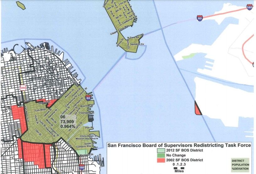
Generally speaking, changes to newly drawn district boundaries are neither huge nor substantial. In most cases, it’s maybe five to ten city blocks. Last time we did this in 2012, the most redrawn district was District 6, which lost a several dozen blocks in the Tenderloin, Hayes Valley, and the Mission, but also spread a little bit into the UCSF Mission Bay Area. (And… part of Alameda used to be in District 6?)
The changes are determined by a nine-person board, appointed equally by the mayor, the supervisors, and the Elections Commission. With all due respect to the people who served on previous redistricting task forces, these are not big political power brokers whom you have heard of. During the last round of redistricting in 2012, they were mostly school board or police commission types who were not household names. Obviously, school board members are something of a more polarizing topic than they’ve been in previous years. But otherwise, we should expect to see a similar caliber of little-known city bureaucrats making these calls.
The odds of your city block getting put into a different supervisor’s district are small. But it is going to happen to, say, probably a hundred or so city blocks and the residents who live on them. And given the San Francisco exodus we saw during the 2020 Census count, analysis by the website Public Comment showed which neighborhoods had the most people move out. Based on those findings, neighborhoods that may see their supervisorial district change could include Nob Hill, the Inner Mission, and Mission Bay.
Related: SF Unlikely To Get Navigation Centers In Every District Despite Supervisor's Push [SFist]
Image: Wikimedia Commons, via the Salem Gazette, Friday, April 2, 1813