A Red Flag Warning goes into effect Monday night that's currently scheduled to expire Wednesday morning. But starting Wednesday evening, PG&E's forecasters are saying there is an elevated risk of another Diablo wind event that could lead to a two- or three-day PSPS (public safety power shutoff) for parts of the North and East Bay and the Santa Cruz Mountains.
It's yet again, once more, deja vu all over again for the weather report this week, with continued dry conditions and offshore breezes — has so-called Indian Summer ever lasted this long or been this consistent?? With no humidity or rain in the forecast and possibly more Diablo winds taking shape that will send gusts over 40 miles per hour over the mountains and ridge tops, tens of thousands of residents in Napa, Sonoma, Solano, Alameda, and possibly Contra Costa, San Mateo, and Santa Cruz counties are looking at another possible PSPS starting Wednesday or Thursday.
The National Weather Service announced a Red Flag Warning beginning Monday at 11 p.m. and extending until Wednesday at 8 a.m. for a wide swath of the Bay Area. Diablo winds sound like they are taking shape for the higher elevations Monday night and possibly Tuesday, but PG&E isn't planning to shut the power off until Wednesday night or Thursday, they're saying.
10- to 25-mph winds coming out of the north/northeast are predicted Monday night with gusts up to 40 mph.
Fire Weather Watch has been upgraded to a🚒🔥Red Flag Warning🚒🔥
— NWS Bay Area (@NWSBayArea) October 19, 2020
Same timing, coverage, winds, and humidity. (North Bay mountains, 11pm Mon-8am Wed, N/NE 10-25mph gust 30-40mph, record dry fuels). https://t.co/QQnfpyB0V1 pic.twitter.com/fLTQvBLeY1
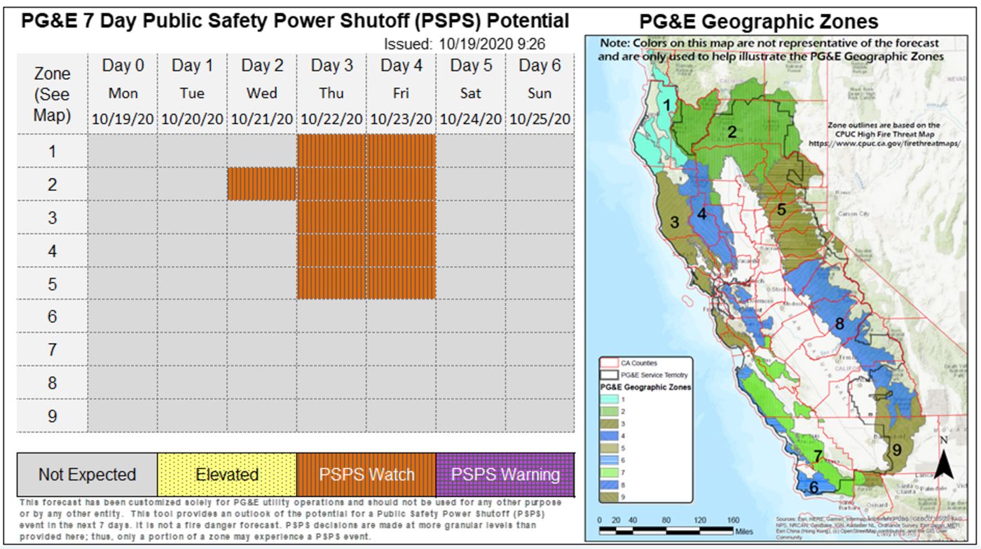
PG&E's warning is being characterized as a "high-level overview," the utility says in a Sunday announcement. "PSPS decisions are made at more granular levels based on high resolution data; thus, only a portion of a zone may experience a PSPS event," PG&E writes.
The Northern Sacramento Valley and adjacent elevated terrain, the Northern Sierra Nevada "generally north of I-80," the North Bay mountains, and the area near Mt. Diablo in the East Bay are currently forecast to have the highest probability of seeing a power shutoff between Wednesday and Thursday. "At this time, the weather event is expected to begin Wednesday night and continue through Friday morning," PG&E says. "The start of the event is more than 3 days away so event details will likely change as forecast models evolve. We will have more clarity on potential cities and counties impacted in the next 48 hours. Please stay tuned to future updates."
You can see the zones potentially impacted below. Update: The situation was upgraded Monday to a PSPS Watch beginning on Wednesday for parts of far Northern California, and beginning Thursday for parts of the North and East Bay.
PG&E's PSPS event last week succeeded insofar as there were no new significant fires in the PSPS zones despite high winds that lasted from Wednesday to Friday. Nonetheless, dry conditions led to several brush fires over the weekend, including one in Vacaville on Saturday that grew to about six acres and forced the evacuation of around 100 homes before being contained.
It sounds like the cycle continues this week, and residents of various hills and mountains around the Bay Area, fatigued after an already long fire season, will be on alert once again. And potentially sitting in hot homes without air conditioning.
Stay strong.
Photo: Ak Ka
This post has been updated to show that the fire weather watch was upgraded to a Red Flag Warning for Monday night.