The second set of tunnels and the viaduct leading from Doyle Drive up to the Golden Gate Bridge approach are set to open on Monday after a major road closure this weekend, and the Chronicle has provided the above video by way of explanation, again, of what's happening.
Looking at the graphic below, provided by PresidioParkway.org, you can see what we have been driving on to get from Lombard Street or the Marina to the bridge for the past three years has been the yellow "Temporary Bypass," which took traffic in both directions around the construction of the two-bore Main Post Tunnels, and into one half of the Battery Tunnels.
As of Monday, the second, north-bound Battery Tunnel will open to traffic for the first time, as will both of the Main Post Tunnels, with the bypass road going away and the new roadways in blue connecting Richardson Ave. and Doyle Drive.
In the meantime, however, traffic is going to be a mess as it's all diverted onto Highway 1 the bridge will remain open, however all ingress and egress from SF will be along one of the tiny on-ramps near the bridge, or via Park Presidio. Doyle Drive and all the tunnels will be closed from 10 p.m. Thursday (tonight!) until 5 a.m. Monday as the new roadway gets built and the temporary one gets removed. As Presidio Parkway spokesperson Molly Graham says, "We expect traffic to be heavy... if people can avoid the corridor, we ask them to do so."
Afterward, the drive will feel much the same for people driving into the city from Marin, but that first Battery Tunnel they've been driving through will feel a lot bigger without any north-bound traffic in it.
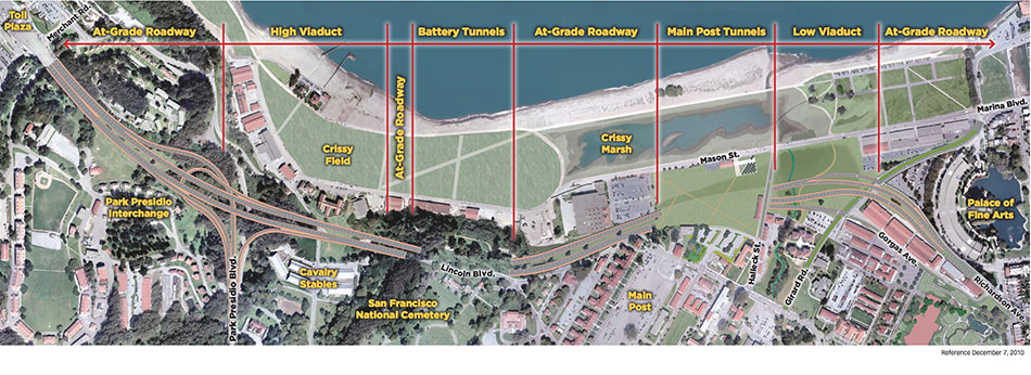
The purpose of all of this apart from providing more lanes for traffic to and from the Golden Gate Bridge and replacing the seismically deficient old viaducts of Doyle Drive will be to provide continuous green space and two pedestrian access points, via greenways, over the tunnels, to walk from the Presidio directly to Crissy Marsh, Crissy Field, and the waterfront. Those landscaped greenways will open by next year, completing the project, which began in 2009. See the complete project map below.
Click to enlarge


