This weekend is supposed to be sunny and balmy here in the city, so what better time than to find at least one thing to do besides day-drink or finish your costume for Bay to Breakers. We offer you some fine ideas for urban hikes in this hilly city of ours, so that you can get some exercise and fresh air without even leaving the 7x7. (Well, barely, in two of these cases.)
Corona Heights
The heart-pounding, near vertical hike to the top of Corona Heights can begin in the Castro: Just take Castro north to 16th, take a left on 16th, and just keep climbing. Once you reach the park, you'll have your choice of trails to follow to the top, a climb that'll take you 520 feet above sea level. Your biggest worry, besides figuring out which view is the most amazing, will be the avoidance of poison oak, that irritating plant that flourishes in the park. Keep your dog (and yourself) on the path and away from plants that look like this or suffer the rashy consequences. — Eve Batey

Fort Funston
Shhhh. Please do not tell anyone how wonderful Fort Funston is. This glorious cliff-top recreation area on the southwestern edge of the city is basically paradise provided you don't get too close to the edge of the cliffs. Abundant parking, occasional hang-gliders, a ton of cool off-leash dogs, gorgeous, often-isolated sand dunes, miles of hikes to explore, and stunning views make this spot by go-to for afternoon hiking. History buffs will enjoy the park's past as a military outpost in World Wars I and II. Even on super-hot days, the ocean breeze is cool, it's pretty empty most of the time, which makes no sense, and there's a very safe sense of community that permeates the few dog people that do wander around. As an added bonus, a pretty decent TJ Maxx is located nearby at Westlake Shopping Center. Beth Spotswood
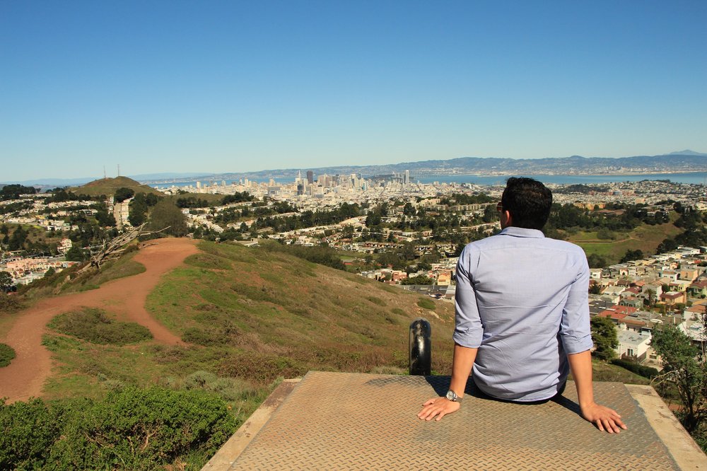
Grand View Park
Marvel at the grandeur of the Pacific atop the Inner Sunset's contribution to this list, Grand View Park, also known, sometimes, as Larsen Peak or Turtle Hill. Approach via the lovely 16th Avenue Tiled Steps, then come the rest of the way up the 666 feet via one of two staircases, one concrete, the other wooden. From the tippy-top, take in all of Golden Gate Park in a beautiful panoramic view rivaling the deYoung's tower. Please stay on the paths as windblown sand from Ocean Beach which built up part of the habitat is eroding and is not replenished due to development. Caleb Pershan


Lands End
Located on San Francisco's northwestern tip, Lands End is home to miles of trails winding through the edge of the continent. There's the Coastal Trail, the El Camino del Mar trail, and the Sutro Ruins Trail, all of which balance accessibility (you are not going to get Blair Witch level lost here, guys) with wild and dangerous nature (the signs warning you away from the cliff edges are no joke). Begin at the beautiful Visitor's Center — that's the evil genius lair-looking structure above the Cliff House — then strike out toward Fort Miley, what's left of the Sutro Baths, or the rebuilt labyrinth. — Eve Batey
Mount Davidson
Mount Davidson is San Francisco's tallest peak at 938 feet tall, and that's not counting the 103-foot concrete cross at the top of it, which was built in 1934 and sold, in 1997, to the Council of Armenian American Organizations of Northern California as a monument for the 1915 Armenian genocide. (Trivia: It was featured in a famous shot in Dirty Harry.) Mount Davidson was once called Blue Mountain for its springtime blooms, but renamed in 1911 after surveyor George Davidson at the behest of the Sierra Club. Onetime SF mayor Adolph Sutro, who once owned most of this land, recruited children to plant trees like blue gum (eucalyptus), not out of the goodness of his heart or due to his love for forests, but instead because of a law that gave tax-free status to forested lands in city limits. As Bay Area Hiker explains, hiking Mount Davidson begins at the bus stop at the intersection of Dalewood and Lansdale, and the trails aren't marked, so despite how small the overall area is, you can still get lost in the woods. Jay Barmann

Photo: Leanne Maxwell/SFist
Nob Hill / Tenderloin
Honored with a song all its own, "Grace Cathedral Park" by Red House Painters, the dog-filled park in front of the cathedral that's actually called Huntington Park is as good a hiking destination as any, even if it means bushwhacking through the wilds of the Tenderloin to get there. You could take the less exciting, more touristed trail known as Powell Street to get there, following the cable car tracks and then hanging a left at California. But you could also start over by Civic Center, head up Larkin, hang a right on Geary or Sutter, and then climb up Taylor Street after you've ducked into a darkened dive bar or three along the way, just to get a real feel for the local fauna. Jay Barmann

San Bruno Mountain State Park
You’re technically not in San Francisco anymore at San Bruno Mountain State Park but you are just immediately south the border of the City and County of San Francisco, and at the 1,319-foot altitude peak of the San Bruno Mountain, you’re at a higher elevation than at any point within San Francisco proper. The elaborate system of trails in San Bruno Mountain State Park will make you feel like you’re in the middle of a Hobbit movie, and one of your best bets to let you escape and forget you’re anywhere near an urban area. You might not recall if you’ve ever seen this mountain or park, but you definitely have in the form of the blinky towers on the Ridge Trail and the “little boxes made of ticky tacky” just outside the park’s borders that served as the inspiration for the 1963 Pete Seeger hit. Joe Kukura

Sign Hill Park
Technically this hike is outside of San Francisco. South San Francisco is home to a famous and (mostly) beloved hillside side proclaiming to all who enter, drive by, or fly into SFO, "SOUTH SAN FRANCISCO THE INDUSTRIAL CITY." And so yeah, you can go off-trail and walk around the big pieces of white concrete, even though the paths sort of guide you away from messing with the sign. But up close, it doesn't look like much. What's cool is that Sign Hill is home to a bunch of other cool stuff, like five short hikes, the endangered Mission Blue butterfly, and a bunch of pretty birds. The views lead east and south, i.e. Brisbane and the airport, which traditionally isn't what people want to look at when gazing around the Bay Area. But we can't all stare at the Salesforce Tower for the rest of our lives and ignore what the rest of this place looks like. Sign Hill feels like an adventure, and a little bit like trespassing. Beth Spotswood

Twin Peaks
Not the David Lynch series being rebooted on Showtime, not the old man bar at Castro and Market with the dubious nickname of “the Glass Coffin”, the original Twin Peaks is the spectacularly scenic, high-altitude 31-acre natural area famed for the three-pronged Sutro Tower that helped you find your sense of direction when you were new in town. In a city of so many outrageously fine panoramic views, it’s tough to argue there’s a better one than Christmas Tree Point, the lookout that dazzles both tourists and grizzled longtime locals alike. While the charms of Twin Peaks are indisputably timeless, some very recent modern upgrades include the downtown-facing side of Twin Peaks Boulevard being reserved for bikes and pedestrians and a Twitter bot that will send you the current view from Twin Peaks. Joe Kukura
Related: The 10 Best Hills In San Francisco
Photo via: We Built This City